

HUMBOLDT COASTAL RESILIENCE PROJECT

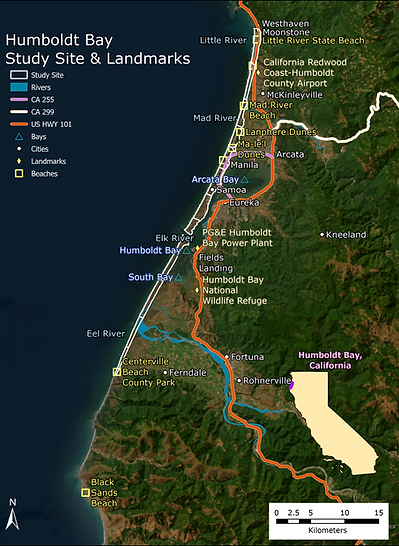
The Humboldt Coastal Resilience Project (HCRP) builds on previous work on the Dunes Climate Ready Project funded by the California State Coastal Conservancy in 2015 to monitor, measure, and characterize historic and modern coastal responses to erosion and sea-level rise in Humboldt County, California. The Humboldt Coastal Resilience Project was funded in 2018 by the California State Coastal Conservancy via a grant awarded to principal investigators Ian Walker (UC Santa Barbara) and Andrea Pickart (US Fish & Wildlife Service) by the California Ocean Protection Council and USC-Sea Grant. The goal of this project was to assess the resilience and broader vulnerabilities of the beach-dune barrier systems of the Eureka Littoral Cell (ELC) to ongoing and future impacts of climate change, including sea level rise and coastal flooding. The ELC shoreline extends roughly 75 km (46 mi) from Trinidad Head in the north to False Cape in the south. This area experiences extreme wave conditions and abundant sand transport and has among the highest rates of SLR on the Pacific coast. The study area for this project only includes locations along the ELC shoreline that host sandy beach-dune barrier systems, which comprise approximately 84.57% (54.44 km) of the total shoreline length (64.37 km).
Recommendations
Based on the project process and results, the project team developed the following recommendations and next steps to explore:
-
Retain sand within the Eureka Littoral Cell system to help maintain the shoreline, beach-dune barriers, protective functions, and coastal access.
-
Utilize multi-level vulnerability analysis as a tool for identifying and assessing various aspects of vulnerability & resilience for a wide range of interests.
-
Foster coordination between decision -making agencies for broader approaches to adaptation due to the interdependency of vulnerabilities and resilience that span geographic scales (local, county, regional/state, federal).
-
Promote proactive, comprehensive planning for land use to facilitate informed adaptation planning (e.g., rezoning, managed retreat, hard engineering, etc.).
-
Consider nature-based solutions (e.g., dune restoration) as an adaptation strategy to increase shoreline resilience where feasible and appropriate.
-
Continue to develop additional information to help identify specific locations/options for adaptation strategies and resilience building.
Why this Study Matters
Protecting Our Coastal Communities: The beaches and dunes around Humboldt Bay and the Eel River delta serve as essential natural barriers, shielding local communities, wildlife habitats, and cultural sites from the forces of the ocean. Preserving these protective landscapes is crucial to maintaining the safety and resilience of our coastal environment and communities.
Responding to Climate Change: As sea levels rise and severe weather events become more frequent, understanding how our coastline is changing is more important than ever. This study provides valuable insights into these changes, helping us to plan and prepare for future impacts, ensuring a more resilient coast for generations to come.


Understanding Baseline Conditions: Cross-Shore Transects and Historic Shoreline Analysis
Through the Dunes Climate Ready Project, Kelsey McDonald (Trinidad to Table Bluff) and GHD (Eel River Shoreline) conducted historic shoreline analyses to understand long-term trends in shoreline movement. This work supported the understanding of historic coastal change along dune systems within the Eureka Littoral Cell (ELC)and established baseline conditions to monitor future shoreline change. The reports are linked below.
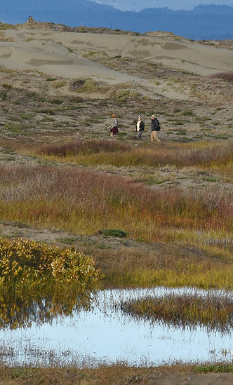
The research team began conducting cross-shore transects in 2016 to document foredune sediment budget, shoreline change, and resiliency of foredunes to erosion within the ELC. . The team conducted two surveys per year for 5 years along 73 transects. Cross-shore transect data collection has continued into 2025 along 28 transects from south of the Mad River to Manila, resulting in 8 years' worth of data at these locations. Transect surveys consist of measuring the elevation from mean high water inland approximately to the deflation plain (the low point immediately inland of the foredune). Vegetation surveys were conducted simultaneously with cross-shore transects to measure vegetation type, cover, and height.
Researchers found that foredune sediment budgets and resiliency differed along the littoral cell. There were two extreme high water events during the study, which allowed for the evaluation of recovery and resilience. In the far north at Little River, there was net deposition and resiliency at Little River/Clam Beach. However, the high foredunes at/south of Mad River County Park were not able to recover from storms, exhibiting a negative sand budget and shoreline retreat. At the Lanphere Adaptation site, the foredune increased in breadth and height as a result of restoration, exhibiting a positive sediment budget and resilient characteristics. From Lanphere to the Humboldt Coastal Nature Center, the foredune sediment budget was neutral to positive, with restored dunes exhibiting resiliency. The southernmost areas of the North Spit underwent dramatic erosion, with a negative sediment budget and a lack of resiliency. The South Spit and Eel River North Spit had lower foredunes but had a neutral to positive sediment budget and were resilient following storms. The Eel River South Spit eroded significantly, with foredune overwash occurring during storms and the complete loss of some stretches of foredune. This area lacked resilience, had a negative sediment budget, and will likely undergo further erosion.

Seeking Future Solutions: Adaptation Sites
The research team tested two adaptation strategies for sea-level rise and extreme weather events at multiple sites along our coastline:
-
ADAPTATION STRATEGY 1: Test the hypothesis that native dune building plants increase resiliency to sea level rise.
-
ADAPTATION STRATEGY 2: Test foredune rebuilding as a method of resisting overtopping by storm surges in sediment-deprived areas.
Lanphere
This site included two control plots: (1) native, non-restored and (2) invasive, and three restored plots revegetated with native species: (3) a native dune grass (Elymus mollis), (4) a low-lying herb and subshrub assemblage (dune mat), and (5) a mixture of the native dune grass and dune mat. The site was monitored using terrestrial LiDAR scanning twice a year between 2015 and 2021. After five years, the restored plots looked different from the invasive plot. Compared to the invasive plots, the native revegetated plots had taller and wider foredunes and recovered their volume and position after storms eroded the foredunes. The invasive foredune took 2 years longer to recover. The researchers concluded that native vegetation helps the foredune recover faster after erosion compared with invasive vegetation, supporting the hypothesis that native dune building plants increase resiliency to sea level rise.
Bair/Waduhl
A second adaptation site was added in the summer of 2019 north of the Lanphere adaptation site. This site differed from the Lanphere site in that no planting was done following the removal of Ammophila arenaria. Revegetation of the foredune was slower here than at the Lanphere site where native species were planted. This allowed researchers to determine the role of planting in promoting resilience.
Eel River
In 2018, the team rebuilt the foredune at a breach site on the Eel River Estuary Preserve with a goal of improving resilience to storm events. The artificial foredune was completely eroded following winter storms. Researchers concluded that foredune rebuilding was not an effective adaptation strategy at a site with a negative sand budget.
- Hilgendorf, Z., Walker, I.J., Pickart, A.J. & Turner, C.M. (2022) Dynamic restoration and the impact of native versus invasive vegetation on coastal foredune morphodynamics, Lanphere Dunes, California, USA. Earth Surface Processes and Landforms, 1–17.
- Lanphere Adaptation Site, Humboldt Coastal Resilience Project. 2024 Report on Vegetation
- Lanphere Adaptation Site Photopoints 2015-2024
- Bair Adaptation Site Progress Report
- Photo-Monitoring Bair Adaptation Site 2024


Updated Tributary Sand Loads and Sand Budget
The Eureka Littoral Cell (ELC) has seen big changes due to human activities and climate change. These changes affect how sand moves along the coast and can profoundly alter the littoral sand budget. The sand budget includes inputs (like river sand) and outputs (like dune growth and shoreline changes). To understand the sand budget, researchers studied how much sand comes from rivers, how much is taken out of Humboldt Bay, and how sea-level change affects the shoreline. Inner-shelf storage and sand loss from rising sea levels play a significant role. They found that traditional methods for measuring sand input from rivers don’t fully capture changes over time. This new study considered more factors and helped to improve our understanding of the ELC sand budget.
Researchers found that the amount of sand reaching the ELC from rivers has decreased since the 1960s due to watershed recovery and better watershed practices. They also concluded that decisions about dredging (removing sand from Humboldt Bay) and river sand and gravel extraction have further reduced sand from the ELC. Before 1990, dredged sand was put back into the ELC, but after 1990, it was disposed of well offshore out of the ELC. Since 2000, dredging has accounted for most of the sand removal. The ELC has been losing sand for 20 years, possibly affecting shorelines and dunes. Researchers further found that if all dredged sand had stayed in the ELC, the sand deficit may have been balanced or significantly reduced.
In summary, the ELC’s sand budget is complex, influenced by natural processes, human actions and climate change, and important for understanding coastal changes. Managing sand wisely is crucial for the ELC’s health and resilience, particularly in the context of future sea-level rise. To prevent or reduce future sand loss and coastal erosion, the researchers suggested that dredged sand from Humboldt Bay be placed back into the ELC instead of disposing it offshore. Reducing river sand and gravel extraction helps too, but prior management decisions have reduced river sand extraction and today it is a smaller part of the problem.

Beach-Dune Barrier Systems Vulnerability Assessment
These beach-dune barrier systems protect nearby ecosystems and communities from erosion, flooding, and rising sea levels. The goal of the Vulnerability Assessment was to understand how the barrier systems along the Eureka Littoral Cell (ELC) would be affected by climate change and rising sea levels.
Researchers divided the study area into 13 sections based on physical features. They looked at 22 different factors, including things like the environment, society, and infrastructure. By combining all this information, they created vulnerability scores and maps to help plan for coastal resilience. These scores range from 1 (least vulnerable) to 10 (most vulnerable). They tell us how likely each area is to be affected by rising sea levels.
Depending on which factors they looked at, vulnerability changed. For example, some areas are more environmentally vulnerable because they’re low-lying or have narrow beach-dune barriers. Others are socio-economically vulnerable due to population and infrastructure. When they combined both environmental and socio-economic factors, they found areas with wide barriers and low population were less vulnerable. But places with more hazards (like erosion and floods) and lots of infrastructure were more vulnerable.
The HCRP aimed to understand how the ELC’s beach-dune barriers would cope with climate change and rising seas, and it provided valuable information for protecting the Humboldt Bay region. This study helps us understand how different areas might be affected by rising sea levels.
DUNES CLIMATE READY GRANT PARTNERS
Us Fish and Wildlife Service, Friends of the Dunes, State Parks, Bureau of Land Management, The Wildlands Conservancy, The University of Victoria’s Coastal Erosion and Dune Dynamics Lab, California Department of Fish and Wildlife, Humboldt Bay Municipal Water District, Flinders University, Arizona State University and the consulting firm GHD.

CLIMATE CHANGE GLOSSARY
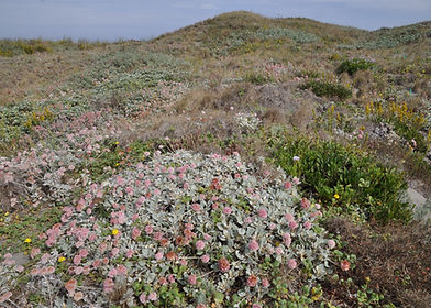
Foredune
The first rise above the beach, and characterized by the native grass Elymus mollis ssp. mollis, which is able to tolerate the intense salt spray and sand deposition that occurs in this habitat.
Vulnerability
The degree to which a system is susceptible to, or unable to cope with, adverse effects of climate change.
Littoral Cell
A natural compartment of the coast that contains a complete cycle of sedimentation.
Adaptation
An adjustment of a natural or human system to a new or change environment that moderates harm or exploits beneficial opportunities.
Sand Budget
A concept used to identify additions and losses of sand that can affect beach width and shape. This can include inputs (like river sand) and outputs (like dune growth and shoreline changes).
Resilience
A capacity to anticipate, prepare for, respond and to recover from climate-change related threats.
Storm surge:
An abnormal rise in sea level accompanying an intense storm or hurricane.